Switzerland’s northern border encircles Geneva before traversing the forested Jura Mountains all the way to the Rhine River, followed by Lake Constance and the Rhine again. I’ll follow the 800-kilometer rim of this fertile Swiss Plateau by bicycle and kayak. The rest the journey—the southern border—is only possible on foot, except for a final paddle down Lake Geneva. Well over 1,100 mountain-filled kilometers traverse four language zones, may cultural boundaries, and a vast number of Switzerland’s most famous summits.
At Swiss Border Photos you’ll find pictures and Google Earth maps that give a greater feeling for some of these sections. At Sample Stories you’ll find a tiny collection of anecdotes that bring various locations to life.
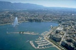
Geneva
The Swiss border circles approximately 90 kilometers around this famously international city. Here John Calvin developed Protestant theology in the 1500s, while in the 21st century the world’s largest accelerator (CERN) smashes subatomic particles in a quest for the elusive “god particle” (among other tiny things). I’ll be crossing over CERN’s massive tunnels as I follow streets for much of this distance, which also negotiates small farms, large backyards, and the Geneva Airport. This highly urbanized region is home to the world—and reflects it well.
Jura Mountains
These limestone hills were named by their ancient Celt settlers as the “forested mountains.” They’re still forested except for patches of farmland and occasional towns. The underground here is laced through with caves like the holes in “Swiss” cheese. Though it’s home to wild gorges, beautiful streams, and fame as the cradle of Swiss watch- and musical box–making, the Jura offers relatively few economic opportunities and is losing population. I’ll bicycle through forests, along ridges, and across canyons and farms while trying to stick to the borderline.
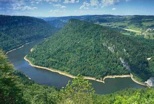
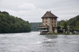
Rhine River
Two-thousand years ago, the Rhine defined the northern boundary of the Roman Empire. To the north were the Germanic tribes; to the south, a diverse mix of conquered Celts and other peoples that a millennium later would coalesce into the first Swiss Confederation. The Rhine flows fast here against my direction of travel, so rather than paddle upstream, I’ll bicycle on roads and trails alongside. The border occasionally leaves the river to carve wild jagged loops to the north, particularly around Schauffhausen, which I’ll follow to learn how it got its strange shape.
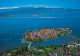
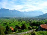
Lake Constance
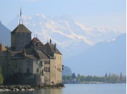
Its real name is the Bodensee, though English-speakers renamed this huge lake after its largest city, Konstanz. Sixty-three kilometers long, Constance is Europe’s third largest lake. With no legal agreement between Germany, Austria, and Switzerland on their exact boundaries, minor disputes arise even today. The greater city of Konstanz (split by the border) has a rich history of reshaping events, especially during the Middle Ages. I will paddle a sea-kayak along the Bodensee, visiting historic sites on both sides of the lake—while looking south to the Alps and my journey to come.
Austria & Liechtenstein
At the Austrian end of Lake Constance, the broad valley of the upper Rhine River sweeps upstream through a short strip of Austria followed by the long edge of a small country called Liechtenstein. The Austrian border here is an important connection to Germany, spanning the brief lowlands connecting the Bodensee and the Alps. I’ll spend a few short days bicycling here at the eastern edge of the Swiss Plateau before leaving the bike and kayak behind for the long crux of my voyage, where boots and crampons replace peddle and paddle at Lichtenstein’s southern border.
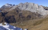
Austria
The hard travel really begins at the Austrian border, where mountains continue one after another. While some of these are rugged (especially in the Silvretta Group) and famous climbing routes sometimes trace the border, much of the Austrian frontier holds trails or at least straightforward high-country travel. A few passes were former trade routes, but no paved roads cross the border until near Italy and the tax-haven of Samnaun. The Austrian border state here—the wealthiest in Austria—elected to join Switzerland in 1919, but was rejected by the Swiss. Nevertheless, there are strong cultural connections.
Northern Italy
My journey wraps around the mostly German-speaking canton of Graubünden, where the south sides of the ridges are very definitely Italian. This is the strongest cultural contrast of all the Swiss borders. There are pockets of Italian speakers inside Graubünden, but the strangest thing here is a language not spoken anywhere else: Romansch. Now that’s a story that I can’t wait to tell. Here also is Switzerland’s first (and still only) national park, which joins at the border with a much-larger Italian national park. It’s a great place to showcase trans-boundary conservation, one of my primary interests. And to climb some serious peaks, especially in the Bregaglia.
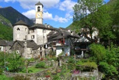
Ticino
Despite it’s mere 300,000 inhabitants, and almost unknown outside Switzerland, Ticino excerpts a strong sway over the entire country. Because Ticinese speak Italian, that tongue is one of Switzerland’s three government languages—and Italian-style culture is an important element in Swiss diversity. Once desperately poor, a large number of Ticinese emigrated to the U.S. in the late 1800s. With large lakes, warm almost Mediterranean climate, and Italian cooking, Ticino is full of surprises. But it won’t be easy, as the elevation gains and losses are radical.
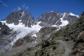
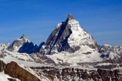
Valais Alps
With the world’s most famous (and beautiful) peak straddling the border, as well as the second-highest peak in the Alps and hundreds more, the frontier between canton Valais and Italy is truly the heart of the Alps—and the story of mountaineering. My border journey climaxes here as I race to climb all the peaks before the first storms of September. I will meet climbers from around the world, and particularly from both sides of the border, and climb more in a month than I have in the last several decades.
French Alps & Lake Geneva
After a long stretch of technical climbing along the ragged granite peaks east of Chamonix, I’ll follow the border as it gradually trends lower until it finally reaches the shore of massive Lake Geneva. This French border is what I gazed at while a youth in Leysin. When I reach Lake Geneva I plan to walk up to my old village, visit friends and my father’s grave, and reflect on how much I loved living here, how long it influenced me, and how great was this journey that will soon come to a close. Then I’ll walk back down to the lake and paddle the Swiss shoreline to Geneva.